Certification Map of Canada

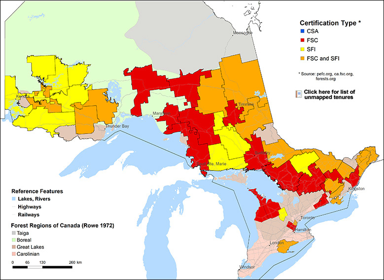
This map shows certified forest lands across Canada. It provides information on forest tenure areas and the certification standards applied to them. Learn more here.

Select Extent: National BC AB SK MB ON QC NB NS NL

Map

ON: Unmapped ON: Trout Lake Forest ON: Kenora Forestlands ON: Missinaibi Forest ON: Missinaibi Forest ON: French-Severn Forest ON: Gordon Cosens Forest - Public Lands ON: Northshore Forest ON: Algoma Forest ON: Boundary Waters Forest ON: Boundary Waters Forest ON: Spanish Forest ON: Sudbury Forest N: Nipissing Forest ON: Algonquin Park Forest ON: Ottawa Valley Forest ON: Hearst Forest ON: Romeo Malette Forest ON: Caribou Forest ON: English River Forest ON: Black Spruce Forest ON: Black Spruce Forest ON: Dog River - Matawin Forest ON: Wabigoon Forest ON: Dryden Forest ON: Dryden Forest ON: Bancroft Minden Forest ON: Mazinaw-Lanark Forest, Quinte Conservation, Northumberland County Forest ON: Timiskaming Forest ON: Abitibi River Forest ON: White River Forest ON: Pineland Forest ON: Kenogami Forest ON: Lac Seul Forest ON: Limerick Forest, Larose Forest, Stormont, Dundas, and Glengarry ON: Oakville, Mississauga, Halton Region ON: Grey, Bruce, and Dufferin Counties ON: Long Point Conservation

How to use the Map

Click on a province to open a detailed provincial view. Then select any coloured block of tenured forest land to see certification details for that area. A Certification Summary will appear, showing:

  • The company holding the tenure certificate
  • The total certified area (in hectares)
  • The standard to which the area is certified
  • The most recent certification audit report and/or Sustainable Forest Management (SFM) plan.

About the Data

Certification data changes regularly. This map represents a snapshot in time, based on the date shown. Updates depend on information being communicated from certification bodies to the standards organizations and are reflected through annual updates. Any corrections should be directed to the relevant standard body (FSC, PEFC Canada, or SFI).

Source

The data comes from the Canadian Certification Status Report, which is updated annually. This map was created for the Forest Products Association of Canada by Dave Baldwin of Spatialworks.